What Country Is K2 In? Complete K2 Location & Route Guide
Where is K2 located?
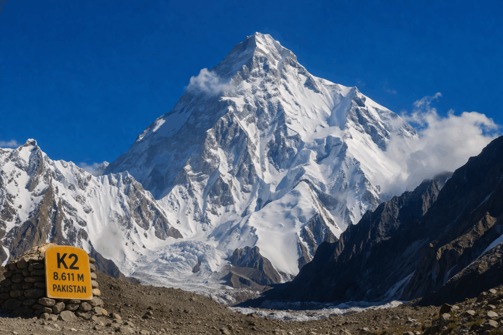
K2 is located in northern Pakistan, on the border between Pakistan and China, within the Karakoram mountain range in the Gilgit-Baltistan region. It stands as the second-highest mountain in the world at 8,611 meters (28,251 feet) and rises in one of the most remote and rugged landscapes on Earth. Positioned deep within the Karakoram, K2 lies near the convergence of massive glacier systems, including the Baltoro Glacier, and is surrounded by a dense cluster of towering peaks.
Unlike many other famous mountains, K2 is not easily accessible. There are no roads leading directly to it, and no nearby cities offering a clear view. Instead, reaching the mountain requires a multi-day journey through valleys, river crossings, and glacier terrain. Because of this isolation, K2 remains one of the least commercialized yet most respected peaks in the world.
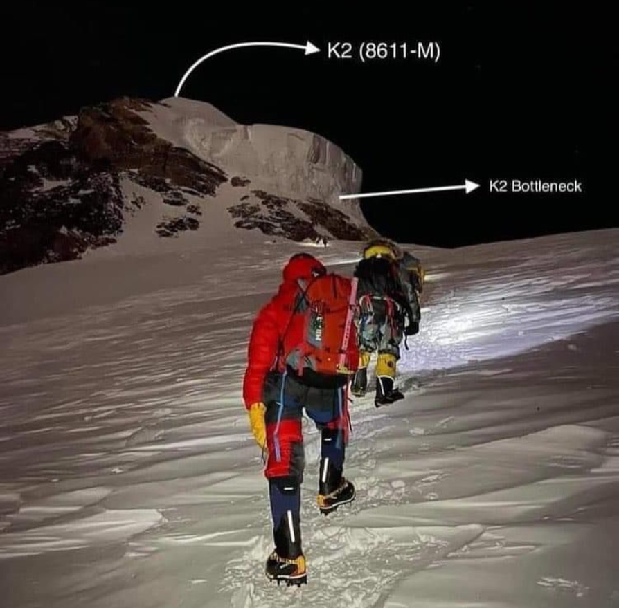
Additionally, its location plays a key role in shaping its reputation. Harsh weather conditions, steep slopes, and technical climbing routes make K2 significantly more challenging than many other high-altitude peaks. As a result, it attracts experienced climbers and serious trekkers who seek both adventure and authenticity in one of the planet’s most untouched mountain environments.
Which Country Is K2 Mountain In?
K2 lies in northern Pakistan, precisely along the international border shared with China. It is situated in the Gilgit-Baltistan region, a remote yet globally recognized area known for its dramatic landscapes and concentration of high peaks.
Although the summit ridge forms part of the Pakistan–China boundary, the standard trekking and climbing routes are entirely located on the Pakistani side. Therefore, nearly all expeditions to K2 are organized through Pakistan, with Skardu serving as the main gateway for travelers and climbers.
Furthermore, this location gives K2 both geographical and strategic importance. Gilgit-Baltistan acts as a hub for mountaineering activities, and K2 stands as one of its most iconic natural landmarks. The region’s unique terrain, combined with its cultural richness, continues to attract adventurers from across the globe.
1. What Mountain Range Is K2 In?
K2 is part of the Karakoram mountain range, one of the most rugged and geologically complex mountain systems in the world. Importantly, it does not belong to the Himalayas, even though many people assume otherwise.
The Karakoram range extends across northern Pakistan, India, and western China. It is characterized by steep, jagged peaks, deep valleys, and extensive glacier systems. In fact, it contains some of the longest glaciers outside the polar regions, including the Baltoro Glacier, which plays a central role in the K2 trekking route.
In contrast, the Himalayas lie further to the southeast and are home to peaks such as Mount Everest. The two ranges are separated by the Indus River, which serves as a natural geographic boundary. This separation is not just visual but also geological.
From a scientific perspective, both ranges were formed by the collision of the Indian and Eurasian tectonic plates. However, the Karakoram developed distinct structural features, including sharper ridgelines and more compact glacial systems. As a result, the terrain in the Karakoram is generally steeper and more technical than in many parts of the Himalayas.
Understanding this distinction is important for trekkers and climbers. The Karakoram demands a higher level of preparation due to its harsher conditions, unpredictable weather, and remote environment. Therefore, knowing that K2 belongs to the Karakoram helps set realistic expectations for anyone planning to explore the region.
2. Is K2 in the Himalayas?
No, K2 is not located in the Himalayas.
Instead, it is part of the Karakoram range, which is a completely separate mountain system. Although both ranges are connected within the broader high-altitude region of Asia, they differ significantly in structure, terrain, and accessibility.
The Indus River clearly separates the Karakoram from the Himalayas. Peaks located to the north of this river, including K2, Broad Peak, and the Gasherbrum group, belong to the Karakoram. Meanwhile, the Himalayan range lies to the south.
This difference is important for several reasons. First, the Karakoram is far less commercialized than the Himalayas. While Everest attracts large numbers of climbers each year, K2 remains relatively untouched. Second, the climbing routes in the Karakoram are more technical and demanding, requiring advanced skills and careful planning.
In addition, weather patterns vary between the two ranges. The Karakoram experiences more extreme and unpredictable conditions, which can change rapidly and impact trekking schedules. Therefore, distinguishing between these ranges is essential for both safety and proper expedition planning.
3. What Are K2’s Exact Coordinates?
The exact coordinates of K2 are:
35.8808° N latitude and 76.5133° E longitude
These coordinates define K2’s precise position on Earth using the global geographic coordinate system. Latitude measures how far north the mountain is from the Equator, while longitude indicates its position east of the Prime Meridian.
For trekkers, climbers, and expedition planners, these coordinates are highly valuable. GPS devices rely on them to provide accurate navigation in areas where trails are not clearly marked. In remote regions like the Karakoram, this level of precision becomes essential for safety and route planning.
When these coordinates are plotted on a map, they place K2 deep within a network of glaciers and high-altitude terrain. One of the most important nearby locations is Concordia, a junction where several glaciers meet. This area is widely regarded as one of the most spectacular viewpoints in the world due to the concentration of massive peaks surrounding it.
Moreover, coordinates help in understanding elevation gain, route direction, and campsite positioning during expeditions. Therefore, they are not just technical details but practical tools that support successful trekking and climbing experiences. For a visual reference, you can explore the exact location through this map:
4. How Far Is K2 From Skardu?
K2 Base Camp is approximately 150 to 160 kilometers from Skardu. However, this distance should not be misunderstood as a simple journey, as the route involves multiple stages and varying terrain.
The journey begins in Skardu, which serves as the main entry point for all K2 expeditions. From there, travelers drive through the Shigar Valley to reach Askole, the last village accessible by road. This drive itself takes several hours and passes through narrow mountain tracks and river crossings.
Once in Askole, the trekking phase begins. The route follows a well-established path:
- Skardu to Shigar
- Shigar to Askole
- Askole to Jhula
- Jhula to Paiju Camp
- Paiju to Urdukas
- Urdukas to Goro II
- Goro II to Concordia
- Concordia to K2 Base Camp
This trek typically takes 8 to 10 days, depending on weather conditions and acclimatization schedules. Each stage involves gradual altitude gain, allowing trekkers to adapt to the thinning air.

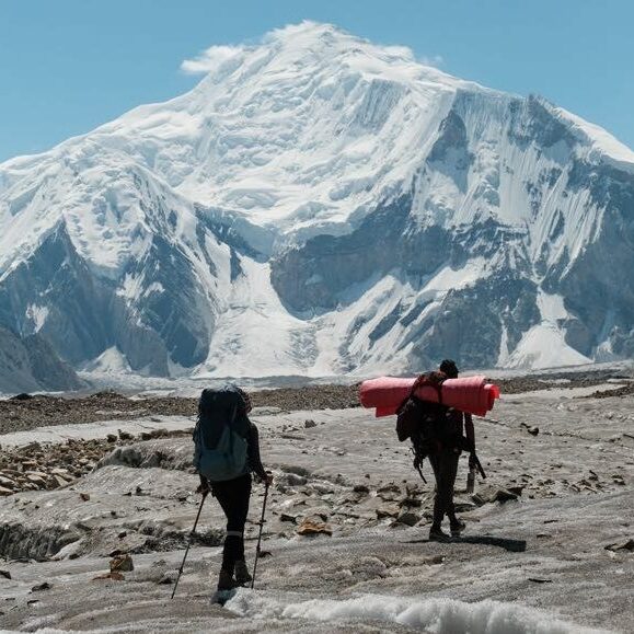
The most challenging part of the journey is walking on the Baltoro Glacier. Trekkers must navigate uneven surfaces, ice formations, and rocky paths while carrying essential gear. Despite these challenges, the route offers unmatched scenery, including views of some of the highest peaks in the world.
Because of its length and difficulty, proper planning, physical preparation, and local guidance are essential for completing this journey safely.
5. What Peaks Surround K2?
K2 is surrounded by some of the highest and most impressive mountains on Earth, forming a dense cluster of peaks within the Karakoram range.
The most notable nearby peaks include:
- Broad Peak (8,051 meters) – Located just a few kilometers from K2, it is one of the closest 8,000-meter peaks and shares a similar base camp region.
- Gasherbrum I (8,080 meters) – Also known as Hidden Peak, it is one of the highest mountains in the Karakoram and part of the same glacier system.
- Gasherbrum II (8,035 meters) – Another prominent peak often climbed in combination with Gasherbrum I.
- Masherbrum (7,821 meters) – Known for its striking pyramid shape, it is visible during the early stages of the trek.
The Karakoram hosts four of the world’s fourteen peaks that rise above 8,000 meters within a relatively compact area around K2. This rare concentration of high mountains makes the region unique and globally significant.
Additionally, the viewpoint at Concordia offers panoramic views of multiple giant peaks, including K2 itself. Because of this, it is often described as one of the greatest mountain viewpoints in the world.
Why Is K2’s Location Considered So Remote?
K2’s location is considered extremely remote due to its distance from major cities, lack of road infrastructure, and challenging terrain. Unlike many other famous mountains, there are no direct transportation routes that lead close to the peak.
The nearest major town is Skardu, which itself requires either a flight or a long road journey to access. From Skardu, travelers must continue toward Askole before beginning the trek. Beyond this point, there are no permanent settlements, modern facilities, or easy evacuation options.
In addition, the entire region is surrounded by high mountain ranges, glaciers, and narrow valleys. This natural isolation makes communication, transportation, and rescue operations more difficult compared to other trekking destinations.
Because of these factors, visiting K2 requires careful planning, experienced guides, and sufficient time for both travel and acclimatization.
Why Is K2 Harder to Access Than Everest?
K2 is widely regarded as more difficult to access than Mount Everest, primarily due to its location and terrain.
First, Everest benefits from well-developed infrastructure on the Nepal side. There are established trekking routes, teahouses, and regular expedition traffic. In contrast, K2 remains largely untouched, with no permanent facilities along the trekking route.
Second, the journey to K2 involves glacier travel for several days, particularly on the Baltoro Glacier. This adds complexity and physical strain, as trekkers must navigate unstable surfaces and changing conditions.
Third, weather conditions in the Karakoram are often harsher and less predictable. Sudden storms, strong winds, and temperature fluctuations can disrupt travel plans and increase risk.
Finally, the remoteness of K2 means that rescue operations are more challenging. Limited access and communication can delay emergency response, making preparation and self-sufficiency even more important.
For these reasons, K2 is not only harder to climb but also more demanding to reach compared to many other high-altitude peaks.
Is K2 visible from Skardu?
No, K2 is not visible from Skardu city because several mountain ranges block the direct line of sight.
Can I see K2 without trekking?
No, there is no road-accessible viewpoint from which K2 can be clearly seen. To experience the mountain, you must trek at least to Concordia or continue to K2 Base Camp.
How long is the trek to K2 base camp from Askole?
The trek from Askole to K2 Base Camp typically takes around 8 to 10 days, depending on weather conditions and acclimatization.
Does K2 border China?
Yes, K2 lies on the border between Pakistan and China. However, the standard trekking and climbing routes are entirely within Pakistan.


Comments are closed