


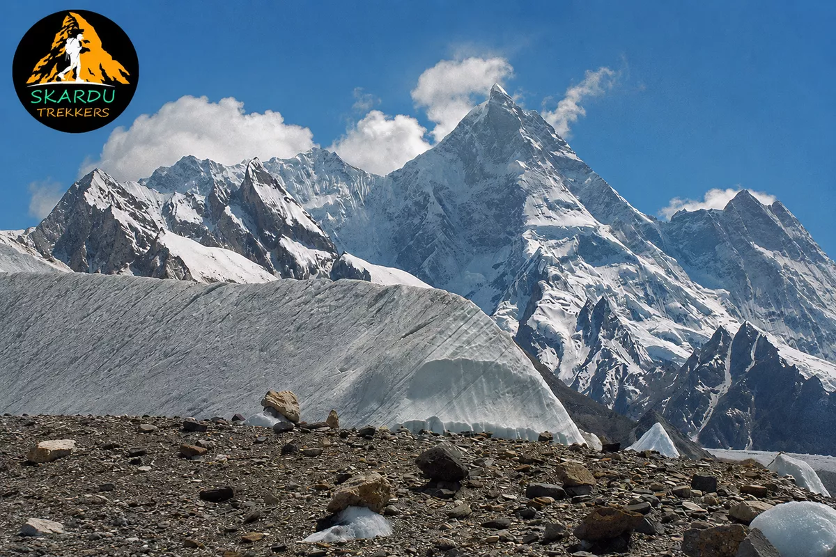
K1 Mountain: The Complete Guide to Masherbrum
K1 is the original surveyor’s designation for Masherbrum, a 7,821m peak in the Karakoram Range of Pakistan. The two names refer to the exact same mountain K1 is simply how it was labeled on the earliest maps of the region, before its local Balti name came into common use.
If you’re researching this peak because you’re planning to climb it, our Masherbrum Expedition is a guided climb to this exact summit. Everything below covers what the name means, where the mountain actually sits, its full climbing history, and how it compares to its far more famous neighbors.
Quick Facts: K1 (Masherbrum) at a Glance
| Modern name | Masherbrum |
| Survey designation | K1 |
| Elevation (main summit) | 7,821m (25,659 ft) |
| Elevation (SW summit) | 7,806m |
| World rank | 22nd highest mountain |
| Pakistan rank | 9th highest peak |
| Location | Ghanche District, Gilgit-Baltistan, Pakistan |
| Range | Masherbrum Mountains, a subrange of the Karakoram |
| First ascent | 1960, George Bell & Willi Unsoeld |
| Standard approach | Hushe Valley |
| Best season | June to September |
Why Is It Called K1 Mountain? The History of the Karakoram Naming System
The “K” naming system dates back to 1856, during the Great Trigonometrical Survey of India. British surveyor Thomas Montgomerie, working from a station roughly 200km away, climbed Mount Haramukh in Kashmir. Looking northeast toward the Karakoram, he sketched the two most prominent peaks visible on the horizon and labeled them simply K1 and K2 “K” for Karakoram, followed by the order in which he recorded them.
Over the following decades, most of the “K” peaks reverted to their local names once explorers and surveyors learned them from communities living nearer the mountains. According to NASA’s Earth Observatory, K1 was renamed Masherbrum once its local name became known but K2 never had a widely used local name reach the surveyors, since it sits in one of the most remote, largely uninhabited corridors of the range, far from any settlement. Its provisional survey code simply stuck. It’s the reason K2 remains one of the very few major peaks on Earth still known primarily by a designation rather than a name.
The Full List of “K” Peaks
Montgomerie’s survey didn’t stop at two. Several other major Karakoram summits still carry, or once carried, their own K-numbers:
| Designation | Modern Name | Elevation |
| K1 | Masherbrum | 7,821m |
| K2 | K2 (Chhogori) | 8,611m |
| K3 | Broad Peak | 8,047m |
| K4 | Gasherbrum II | 8,035m |
| K5 | Gasherbrum I | 8,080m |
| K6 | K6 (Baltistan Peak) | 7,282m |
| K7 | K7 | 6,942m |
| K12 | K12 | 7,428m |
Notice the pattern: K1 through K5 are all higher-profile peaks that carry local or English names today. K2, K6, and K7 are the outliers that kept their survey codes again, largely because no single local name for them was well established at the time surveyors passed through. If you’re climbing in this region, our K2 Expedition takes you to the most famous of these survey-numbered giants.
K1 Mountain Height & Topography: How Tall Is Masherbrum?
- Elevation: 7,821 meters (25,659 feet)
- World ranking: 22nd highest mountain on Earth
- National ranking: 9th highest peak in Pakistan
Masherbrum isn’t a single point it’s a massif with two summits. The main (north) summit reaches 7,821m, while a separate southwest summit stands slightly lower at 7,806m. Both have been climbed, though only rarely; Masherbrum has one of the lowest ascent counts of any peak above 7,500m in the Karakoram.
The mountain is known for its notoriously steep granite walls and technical ridgelines, which is part of why it draws far fewer expeditions than its 8,000m neighbors despite sitting well within reach of them geographically. Its distinctive profile, visible from the Hushe Valley below, has earned it comparisons to the Matterhorn a sharp, singular summit rather than a broad massif, which is unusual for a peak of this size in the Karakoram.
Why So Few Climbers Attempt It
Unlike K2 or the Gasherbrums, Masherbrum sees only a handful of expeditions in any given year. Three factors explain why: its steep granite walls demand serious technical rock and ice skill rather than a straightforward glacier walk; its remoteness down the separate Hushe Valley corridor means less established infrastructure than the well-trodden Baltoro route; and its avalanche-prone slopes make timing the climbing window especially important. The result is a mountain that, despite standing well under 8,000m, has a lower successful-ascent count than several peaks nearly a thousand meters taller.
Ready to Take on Masherbrum (K1)?
Attempt the 7,821-meter Masherbrum with a guided expedition through the Hushe Valley. Get local expedition support, route planning, permits, logistics, and high-altitude guidance for this technical Karakoram objective.
Where Is K1 Mountain Located? Geographical Coordinates and Range
Masherbrum stands in the Ghanche District of Gilgit-Baltistan, Pakistan, south of the Baltoro Glacier on the opposite side of the main Karakoram crest from K2 and the other 8,000m giants. It’s the highest peak of the Masherbrum Mountains, a subrange of the Karakoram that also includes Chogolisa (7,665m) and K6 (7,281m).
Most expeditions reach it via the Hushe Valley, in the same Khaplu Valley region of Ghanche District a different approach corridor from the Baltoro route used for K2, Broad Peak, and the Gasherbrums. That means a Masherbrum expedition sees a genuinely different side of the Karakoram than the standard Baltoro trek, passing through Balti villages rather than the busier glacier highway most trekkers follow.
A quick clarification, since this causes real confusion: unlike Mount Everest, which sits in the Himalayas on the border of Nepal and China, K1 rests entirely within the Karakoram Range in Pakistan. The two mountains aren’t in the same country, the same range, or even the same part of Asia the only thing they share is the informal “K” numbering system’s coincidental proximity in naming convention to K2, which itself is unrelated to Everest.
K1 vs. K2 vs. Everest: Clearing Up the Ultimate Mountain Misconception
A common misconception is that “K1” should logically be taller than K2 or even the tallest mountain on Earth because the number comes first. Neither is true. The numbers reflect only the order in which Thomas Montgomerie sketched and recorded the peaks during his 1856 survey, not their height ranking.
| Mountain | Alternative Name | Elevation | Global Rank | Range | Country |
| Mount Everest | Sagarmatha / Chomolungma | 8,849m | 1st | Himalayas | Nepal / China |
| K2 | Mount Godwin-Austen / Chhogori | 8,611m | 2nd | Karakoram | Pakistan / China |
| K1 | Masherbrum | 7,821m | 22nd | Karakoram | Pakistan |
Masherbrum is a serious, genuinely difficult 7,000m peak but it’s roughly 1,000m shorter than K2 and nearly 1,700m shorter than Everest, and sits far down the world ranking rather than at the top of it. All three mountains also sit in entirely different ranges and countries, despite the naming coincidence that leads so many people to search for a connection between them.
The Climbing History of Masherbrum
Masherbrum was first reconnoitered from a distance in 1911 by explorers Fanny Bullock Workman and William Hunter Workman. The first real attempt on the mountain came in 1938, when a British team led by James Waller which included Dawa Thondup and J.O.M. Roberts pushed to around 7,600m from the south before deep snow forced them to turn back, just short of the summit. It was a remarkably close attempt for the era, and it would be another 22 years before anyone tried again with success.
The first successful ascent came in 1960. An American-Pakistani expedition, organized under the leadership of Nick Clinch, put climbers George Bell and Willi Unsoeld on the main summit via the southwest face, reportedly in July of that year. It remains one of the notable early successes of international Karakoram mountaineering, coming after two decades of failed attempts and marking one of the first major joint US-Pakistani mountaineering achievements in the region.
The lower southwest summit wasn’t climbed until 1981, by a Polish team and that ascent ended in tragedy, with two of the three summiteers dying during the descent. It’s a sobering reminder that even Masherbrum’s “secondary” summit is a serious mountaineering objective in its own right, not a lesser consolation prize next to the main peak.
Since then, Masherbrum has remained one of the least-climbed peaks of its height in the Karakoram, overshadowed by its higher 8,000m neighbors just across the Baltoro corridor which is exactly what makes it appealing to climbers looking for a genuinely committing objective away from the more crowded routes.
When to Climb Masherbrum: Season and Conditions
Like most Karakoram peaks, the climbing window runs from June through September, when temperatures are highest and the risk of heavy snowfall is lowest. Even within that window, conditions on Masherbrum’s steep faces can shift quickly the same granite walls that make the mountain visually striking also hold less snow cover to stabilize loose rock, and the surrounding slopes are known for avalanche activity, particularly earlier in the season. Expeditions typically build in extra acclimatization days at Hushe Valley camps before pushing toward the upper mountain, given both the altitude and the technical demands of the final approach.
Planning a Masherbrum Expedition?
Find out what it takes to attempt K1, including the climbing season, Hushe Valley approach, expedition logistics, permits, acclimatization, and required preparation.
Frequently Asked Questions
Is K1 the tallest mountain?
No. K1 (Masherbrum) is the 22nd highest mountain in the world, at 7,821m far below Everest (1st) and K2 (2nd).
What mountain is called K1?
Masherbrum, a 7,821m peak in the Karakoram Range of Gilgit-Baltistan, Pakistan.
Has anyone climbed K1?
Yes. The main summit was first climbed in 1960 by George Bell and Willi Unsoeld, part of an American-Pakistani expedition led by Nick Clinch. The lower southwest summit was first climbed in 1981 by a Polish team.
Is K1 the same mountain as K2?
No, they’re separate, unrelated peaks. K1 (Masherbrum, 7,821m) sits south of the Baltoro Glacier; K2 (8,611m) rises from the main Karakoram crest to the north. They share only the “K” survey-naming convention from the same 1856 expedition.
Where is K1 located?
In the Ghanche District of Gilgit-Baltistan, Pakistan, reached via the Hushe Valley a separate approach from the Baltoro Glacier route used for K2 and the region’s 8,000m peaks.
Why is Masherbrum so rarely climbed compared to nearby 8,000m peaks?
Its steep granite walls demand more technical rock and ice climbing than the glacier routes on nearby giants like K2 or the Gasherbrums, and its remote Hushe Valley approach has less established infrastructure than the main Baltoro corridor.
Climb Masherbrum Yourself
Masherbrum remains one of the Karakoram’s most under-climbed major peaks a genuine technical objective, away from the crowds on the Baltoro route. Our Masherbrum Expedition takes climbers into the Hushe Valley to attempt this exact mountain. If you’re building altitude experience first, our Laila Peak Expedition shares the same Hushe Valley approach and is a popular warm-up objective before a 7,000m attempt like this one. All expedition permits are arranged through the Alpine Club of Pakistan, the country’s national mountaineering federation.
Contact us to start planning your Masherbrum (K1) expedition.



Comments are closed